
The Historic County Borders Project
The Historic County Borders Project has digitised the borders of the historic counties of the UK and made them freely available for public and commercial use. The data can be downloaded below.
The project's aims and methodology are described in detail in the Project Description.
The project is closely based on the Historic Counties Standard, which provides a comprehensive definition of the names, areas and borders of the historic counties of the UK. Users of the data from the Project are advised to become familiar with the Standard. The Historic Counties Standard contains two definitions in relation to the treatment of detached parts. The data for both definitions (A and B) are provided.
The data are available in 6 formats:
- ArcGIS SHP format on the World Geodetic System (WGS84) coordinate system - 1:5,000
- ArcGIS SHP format on the OS National Grid (OSGB36) grid-reference system - 1:5,000
- Google Earth KMZ format on the World Geodetic System (WGS84) coordinate system - 1:5,000
- ArcGIS SHP format on the World Geodetic System (WGS84) coordinate system - simplified
- ArcGIS SHP format on the OS National Grid (OSGB36) grid-reference system - simplified
- Google Earth KMZ format on the World Geodetic System (WGS84) coordinate system - simplified
The full-resolution (1:5000) versions are suitable for detailed large-scale mapping. The simplified versions are more likely to be suitable for use with small-scale mapping.
Historic Counties Standard Definition A:
- Definition A: SHP WGS84 Full Resolution 41.11 MB
- Definition A: SHP OSGB36 Full Resolution 41.37 MB
- Definition A: KMZ WGS84 Full Resolution 45.68 MB
- Definition A: SHP WGS84 Simplified 4.97 MB
- Definition A: SHP OSGB36 Simplified 5.14 MB
- Definition A: KMZ WGS84 Simplified 5.5 MB
Historic Counties Standard Definition B:
- Definition B: SHP WGS84 Full Resolution 42.65 MB
- Definition B: SHP OSGB36 Full Resolution 42.9 MB
- Definition B: KMZ WGS84 Full Resolution 47.37 MB
- Definition B: SHP WGS84 Simplified 5.19 MB
- Definition B: SHP OSGB36 Simplified 5.37 MB
- Definition B: KMZ WGS84 Simplified 5.74 MB
Last updated on 30 July 2026.
Terms of Data Use
The data are provided free of charge for all personal, educational, non-commercial and commercial use. No specific permission is required. However, the Historic Counties Trust would appreciate an appropriate acknowledgement of the use of the data, along the lines of:
"This [project/mapping/website/publication etc.] made use of data provided by the Historic County Borders Project."
For web publications, this statement should contain a link to the Project web site, https://county-borders.co.uk.
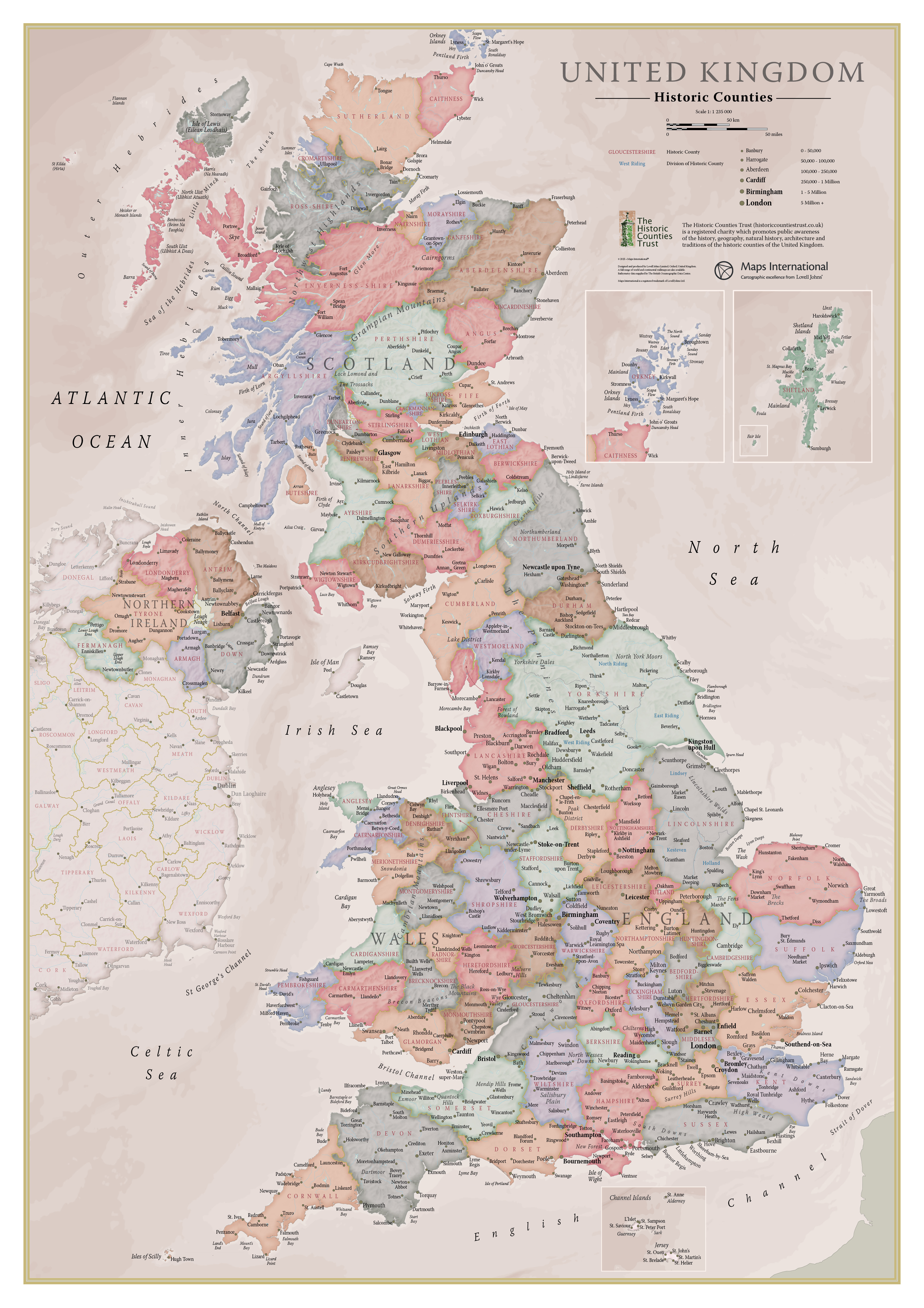
Wall Map of the Historic Counties of the United Kingdom
Created for the Historic Counties Trust by the expert cartographers of Lovell Johns, this A1 wall map features each of the 92 historic counties, as well as the Ridings of Yorkshire and the Parts of Lincolnshire. Major towns and cities are highlighted, along with hill and sea shading. The map is available from Stanfords map shop for £9.99 + P&P.
© Historic Counties Trust 2026 · Registered Charity No. 1114371 · enquiries@historiccountiestrust.co.uk · About Us